
Cairo’s Metropolitan Landscape: Segregation Extreme
The following is an excerpt from Abdelbaseer Mohamed’s “Cairo’s Metropolitan Landscape: Segregation Extreme” article. Follow the link below the text for the full article.
The urban growth patterns of the Cairo metropolitan area reveal a fragmented city of heterogeneous parts. As an urbanist and Cairo native I tend to see the city as a series of small islands isolated from one another by strong physical barriers. Walls, highways, flyovers, military sites, abandoned waterfronts, parking lots and vacant lands all contribute to a city that is characterised by a fundamental lack of cohesion. What is more, there is no public realm that accommodates different communities. Rather, each social group is confined to a separate enclave.
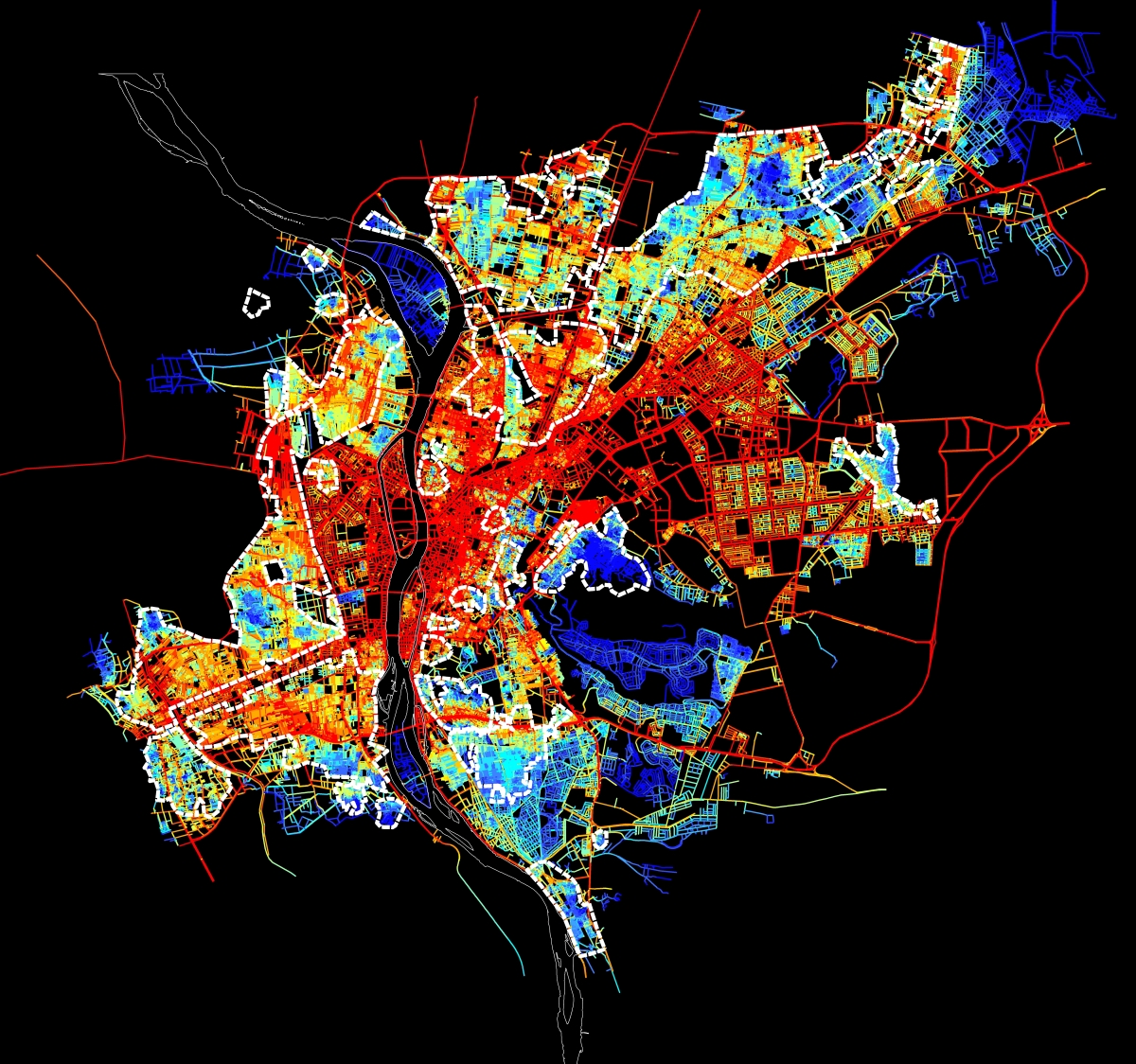
Spatial accessibility map for the urban agglomeration within the Ring RD. Red means integrated and accessible, while blue is segregated.
A long History of Urban Segregation
Urban segregation has been a continual feature of Cairo’s history. Fatimid Cairo (969) was a walled-city exclusively established for the ruling elite. In the Ottoman period (1517-1798), a Hara, mainly a gated residential quarter, was the basic urban unit of the city. Poor harat were located on the peripheries, while the wealthy bourgeois could be found in the centre. As Egyptian sociologist Nawal al-Messiri puts it, ‘Living in a hara, especially a closed hara, was like living in one’s own kingdom. The area was supervised and no person from the outside could enter’. These dynamics persisted into the Mamluk period, during which emirs would cluster around the outskirts of the city and surround their houses with gardens to segregate themselves from the citizens. More recently, the Khedivial city (1869), which was intended mainly for foreigners and wealthy Egyptians, was erected on vacant land west of the old city (although it eventually came to house the working class). By studying the city’s long history it becomes clear that Cairo is like a cracked vase, where fractures over many centuries have been etched into its physical memory. A cursory look at the more recent history of Cairo reveals that these fractures have persisted into the modern day.
Click here for the full article: http://www.failedarchitecture.com/cairos-metropolitan-landscape-segregation-extreme/
Abdelbaseer A. Mohamed is an architect and urban planner. Mohamed received his MSc in Urban planning and Design from Ain Shams University, where he is currently working on his PhD. He is mainly interested in studying the influence of urban space on society adopting a configurational approach, space syntax. Mohamed is currently a Carnegie fellow at American University in Washington.


Reblogged this on The non-standard user.
Reblogged this on urbanculturalstudies.