
Cairo’s Metropolitan Landscape: Segregation Extreme – Now in Arabic!
[Note: Complete text in English below]
فيما يلي مقتطفات من مقال “محيط العاصمة القاهرة : الفصل المتطرف ” لكاتبه عبدالبصير محمد، لقراءة نص المقال كاملاً اتبع الرابط في الأسفل.
تكشف أنماط التوسع العمراني لمنطقة العاصمة القاهرة عن مدينة مفتتة لأجزاء غير متجانسة، فبإعتباري متخصص تخطيط عمراني وأيضاً قاهري، فأنا أميل إلي توصيف المدينة كسلسلة من الجزر الصغيرة المنعزلة عن بعضها بحواجز مادية مُحكمة: جدران، طرق سريعة، كباري عُلوية، مواقع عسكرية، وجهات مائية مهجورة، مواقف سيارات وأراضي شاغرة تتشارك جميعها في مدينة سمتها الأساسية نقص الاتساق والتجانس، بالإضافة إلي عدم وجود أماكن عامة تستوعب الفئات المجتمعية المختلفة، بل وتقوم كل فئة اجتماعية بحصر نفسها في حي منفصل على الأحرى.
تاريخ حافل من الفصل العمراني
يعتبر الفصل و التمييز العمراني سمة متأصلة في تاريخ القاهرة، فالقاهرة الفاطمية ( 969 م) كانت مدينة مسورة بالجدران أنشأت للنُخبة الحاكمة بشكل حصري، وفي العصر العثماني ( م1517- م 1798)، كانت الحارة -حي سكني مسوَّر على الأغلب- هي وحدة العمران الأساسية للمدينة، حيث تقع الحارات الفقيرة على أطرافها بينما الحارات البرجوازية والثرية يمكن أن نجدها في المركز، وعلى حد قول عالمة الاجتماع المصرية نوال المسيري “فالعيش في حارة، المغلق منها على وجه الخصوص، كان كالعيش في مملكة خاصة بالمرء، فالمنطقة كانت تحت إشراف ولم يسمح لأي شخص من الخارج بالدخول”،واستمرت هذة المحركات في العصر المملوكي، فقام الأمراء بإحاطة ضواحي المدينة بتكتلات وسوروا بيوتهم بالحدائق كي يعزلوا أنفسهم عن عامة الشعب، ومنذ عهد أقرب، بالمدينة الخديوية (م1869) – والتي اعدت بشكل رئيسي للأجانب والمصريين الأثرياء- فشيدت على أرض شاغرة في غرب المدينة القديمة (إلا أنها احتوت على مساكن الطبقة العاملة في نهاية الأمر). إن دراسة تاريخ المدينة الحافل يوضح لنا أن القاهرة أشبه بالإناء المتصدع الذي تم حفر هذة الكسور في ذاكرته عبر القرون، وبنظرة خاطفة على تاريخ القاهرة الحديث يتضح لنا أن هذة الكسور مستمرة إلي يومنا هذا.
لنص المقال الكامل، اضغط هنا http://www.failedarchitecture.com/cairos-metropolitan-landscape-segregation-extreme/
عبدالبصير محمد معماري ومخطط عمراني، حصل على درجة الماجستير في التصميم والتخطيط العمراني من جامعة عين شمس، حيث يعمل على درجة الدكتوراه. يهتم محمد بدراسة تأثير المساحة العمرانية على المتجمع، متبنياً منهج تركيبي، بناء المساحة، وحالياً زميل في برنامج كارنيجي بالجامعة الأمريكية في واشنطن.
The following is an excerpt from Abdelbaseer Mohamed’s “Cairo’s Metropolitan Landscape: Segregation Extreme” article. Follow the link below the text for the full article.
The urban growth patterns of the Cairo metropolitan area reveal a fragmented city of heterogeneous parts. As an urbanist and Cairo native I tend to see the city as a series of small islands isolated from one another by strong physical barriers. Walls, highways, flyovers, military sites, abandoned waterfronts, parking lots and vacant lands all contribute to a city that is characterised by a fundamental lack of cohesion. What is more, there is no public realm that accommodates different communities. Rather, each social group is confined to a separate enclave.
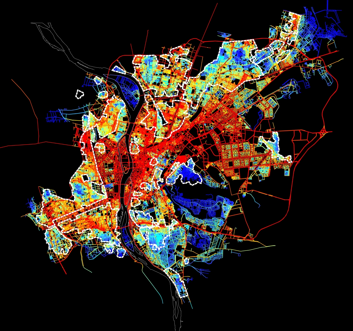
Spatial accessibility map for the urban agglomeration within the Ring RD. Red means integrated and accessible, while blue is segregated.
A long History of Urban Segregation
Urban segregation has been a continual feature of Cairo’s history. Fatimid Cairo (969) was a walled-city exclusively established for the ruling elite. In the Ottoman period (1517-1798), a Hara, mainly a gated residential quarter, was the basic urban unit of the city. Poor harat were located on the peripheries, while the wealthy bourgeois could be found in the centre. As Egyptian sociologist Nawal al-Messiri puts it, ‘Living in a hara, especially a closed hara, was like living in one’s own kingdom. The area was supervised and no person from the outside could enter’. These dynamics persisted into the Mamluk period, during which emirs would cluster around the outskirts of the city and surround their houses with gardens to segregate themselves from the citizens. More recently, the Khedivial city (1869), which was intended mainly for foreigners and wealthy Egyptians, was erected on vacant land west of the old city (although it eventually came to house the working class). By studying the city’s long history it becomes clear that Cairo is like a cracked vase, where fractures over many centuries have been etched into its physical memory. A cursory look at the more recent history of Cairo reveals that these fractures have persisted into the modern day.
Click here for the full article: http://www.failedarchitecture.com/cairos-metropolitan-landscape-segregation-extreme/
Abdelbaseer A. Mohamed is an architect and urban planner. Mohamed received his MSc in Urban planning and Design from Ain Shams University, where he is currently working on his PhD. He is mainly interested in studying the influence of urban space on society adopting a configurational approach, space syntax. Mohamed is currently a Carnegie fellow at American University in Washington.
Translation credit: Radwa Yassin is a fresh Building Engineering graduate from Ain Shams University. Yassin is specialized in Environmental and Sustainable Design, and is currently working as a Business development and Proposals Engineer. She is mainly interested in integrated solutions for planning and designing cities and buildings.
رضوى ياسين مهندسة بناء حديثة التخرج من جامعة عين شمس، متخصصة في التصميم البيئي المستدام، وتعمل حالياً كمهندسة عطاءات وتنمية أعمال. تهتم ياسين بدراسة الحلول المتكاملة لتخطيط وتصميم المدن والمباني.


Please share your thoughts and join the debate